![Introducing the General Zebulon Montgomery Pike INTERNational Historic Trail [ZPIT]](../../../../wp-content/uploads/2018/07/21-St-Anthony-Falls-144dpi-wm-150x150.jpg)

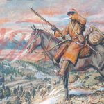
Pike in Wisconsin (1st Expedition)
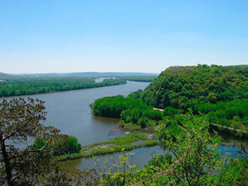
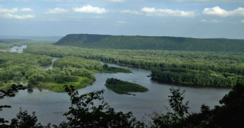
Of the 16 days they spent in Wisconsin (or adjacent IA and MN) on the ascent of the Mississippi River, eight encampments were in Wisconsin and one on an island.
On the return trip the 10 days spent in Wisconsin (or adjacent MN/IA) they encamped in Wisconsin 2 times. They were moving more quickly downstream albeit through rapids. Pike completed his responsibilities started on the ascent. They returned to their encampments at Red Wing, MN (4/13&14) to finish business, Wabasha, MN below Lake Pepin (4/15), Brownsville, MN (4/16), Mississippi Island # 10 (4/17), Prairie du Chien (4/18 to 22), and back at the Mines of Spain and Julien Dubuque (4/23).
The Indians had made temporary peace. Pike had surveyed land for future American fort sites and he made American presence known among the Indians and the French.
French Influence in Wisconsin
Pike’s Expeditions visited many French settlements on the Mississippi and Missouri Rivers. The French influence in North America is evident in many locations. The French settled along the St. Lawrence Seaway in Montreal and Quebec City in French speaking Quebec, Canada. The French influence in Canada spread on the Great Lakes to Lake Michigan. Sault Ste. Marie was settled by the French.
 In May 1673, Father Jacques Marquette and fur trader Louis Joliet ascended the Fox River at Green Bay, portaged to the Wisconsin River and entered the Mississippi near Prairie du Chien on June 17, 1673. They stopped at the Arkansas River (435 miles from the Gulf of Mexico) because it flowed through hostile Spanish domains. They returned to Montreal on the Illinois River in mid-July.
France controlled the Louisiana Territory from 1699 until ceding it to Spain in 1762. France regained Louisiana in 1800 when Napoleon hoped to re-establish the French empire in North America.
Vente de la Louisiane - The Louisiana Purchase
American Founding Fathers James Monroe and Robert R. Livingston purchased the Louisiana Territory from Napoleon in 1803.
During his lifetime, Pike visited French settlements and leaders along the Mississippi River in La Crosse, Prairie des Chien, BelleFontaine, St. Louis, as well as French settlements on the Missouri River. The French had influence over trading and the native population which was needed by the American government. Sainte-Geneviève, MO and Prairie du Rocher, IL were settled by the French.
Pike in Prairie de Chien, WS
 Prairie du Chien was important to trade on the Mississippi between the French, British, native population and American traders. It was a go-to location. Pike gave rides to companions he met on his trip to and from Prairie du Chien. He met Indians from the lower band of the Sioux in this town as well as Menominee and began talks with them. American traders James Fraser, Judge Fisher, John Woods “appeared to be spontaneous effusions of good will, and exultations in their countremen; for it ever extended to the accommodation, convenience, pasttimes, exercises &c. of my men; and wherever they proved superior to the French, openly shewed their pleasure.” -Pike 7th Sep. 1805
Between 9/4 to 6, (1805) Pike hired Pierre Roseau and Joseph Rienville as interpreters and purchased replacement boats for his awkward keelboat. On the return trip the Pike party remained there (4/18-22) to complete business.
 “Arrived at the Prairie Des Chiens at two OClock & were received by crowds on the Bank. Took up my quarters at Mr. Fishers. My men received a present of one Barrel of Pork from Mr. Campbell— also a Bag of Biscuit— also 20 loaves of Bread and some meat from Mr. Fisher. … I was called on by a number of Chiefs—— Reynards, Sioux of the Des Moyen &c. The Winebagos were here.” ~ Pike 4/18
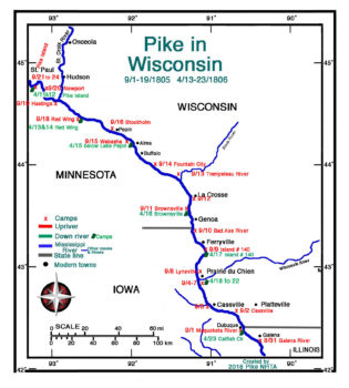
Pike’s field maps (below) are excellent. Matches are good when overlaid on modern maps or compared to the modern map above. The two Pike Field Maps included line up north to south with each other. Plate 13 above 12.
PIKE’S FIELD MAPS- Plates 12 and 13

