![Introducing the General Zebulon Montgomery Pike INTERNational Historic Trail [ZPIT]](../../../../wp-content/uploads/2018/07/21-St-Anthony-Falls-144dpi-wm-150x150.jpg)

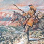

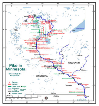
Pike in Minnesota (1st Expedition)
Among Pike’s missions during the first expedition were to:
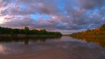
- explore, map and gather information on the Upper Mississippi River from St. Louis to the then considered headwaters - Cass Lake, MN
- seek peace among the native population
- survey land for future American forts
- challenge the British to abide by the American territorial rules.
 Of the 217 days they spent in Minnesota (or adjacent Wisconsin) 160 days were spent on the ascent of the Mississippi River and 57 days in the descent.
The long periods of time spend in Minnesota involved two factors. Pike had to care for unfinished business trying to gain peace among the tribes and the long Swan River stockade encampment (south of today’s Little Falls, MN).
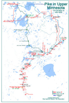
Pike in Upper Minnesota
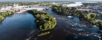
On their entry into Minnesota on September 5, 1805 (adjacent WS), they continued to be obliged to drag their boats through rapids and falls.
At the Falls of St. Anthony (Minneapolis) they portaged their crafts taking 5 days (2 days on descent).
When they arrived north of today’s St. Cloud nearly to Little Falls on October 16th, Pike realized that they needed to stop because his Sergeant, Corporal and others were losing quantities of blood from pulling the boats over shallow areas.
With cold and snow falling he realized that the boats were becoming useless and that changes had to be made. The Swan River area was teaming with game which served them well during the 192 days spent at this stockade by the full crew or the 3 manning the stockade in the absence hunters/travelers.
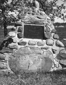
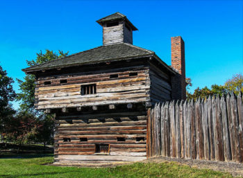
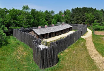
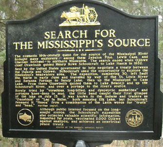
The Little Falls / Swan River Stockade
 This stockade on today’s Zebulon Pike Lake was occupied for 53 days from October 16th to December 8 on ascent waiting for the Mississippi to freeze.
The boats they were using no longer were useful. They prepared sleds for the journey to Cass and Leech Lake.
 They reoccupied this stockade for 32 days from March 5, 1806 to April 6 waiting for the Mississippi to thaw so that the boats could once again be used.
During the 87 days the party traveled north, the stockade was manned by men: Sergeant Kenneman (who turned out to be considered a fool, giving away “whiskey, saddles of venison and hams” that Pike was saving for the return voyage); Corporal Meek and a private.
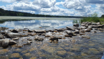
The stockade foundations were found prior to the building of Blanchard Dam on the Mississippi creating today’s Zebulon Pike Lake.
This Pike Stockade monument was erected at the Swan River above Zebulon Pike Lake (photo courtesy Little Falls Museum).
The British
 The British had been trading with the Indians in northern Minnesota for decades.
Now that it was American territory several adjustments has to be made.
Pike and his men met numbers of British agents in Minnesota and were cordially greeted and helped by them. Pike was shown trails and lodged in numbers of British Northwest Company forts. They were welcomed and they found shelter from the cold and snow at Lake De Sable (today’s Big Sandy) near Aitken; the NW Co fort north in Grand Rapids; the fort on Steamboat Bay near Benedict, MN on Leech Lake and fort on the north side of Cass Lake near today’s Pennington, MN.
Pike had business with the British. The British were flying the British flag over their establishments, handing out British medallions to the Indians, trading with the Indians to the disadvantage of American traders, and not paying tariffs agreed upon in treaty. Pike’s men shot down a British flag and replaced with the American 15 star flag.
 In a lengthy letter to Mr. Hugh M’Gillis, proprietor of the British Northwest Company and director of the Fond du Lac department, on 6 February 1806, written at, and delivered at, Leech Lake, MN, Pike wrote a scathing rebuke of British practices since the Louisiana Purchase and subsequent treaties.
In a letter from M’Gillis delivered to Pike before Pike’s departure on February 19th, M’Gillis apologized and promised not to continue their practices. He only asked that the tariff for that year be excused. All future tariffs would be honored.
 We believe these promises may, in large part, have been kept by the British.
A copy of these two letters can be found in: Jackson, Don; Journals of Zebulon Montgomery Pike, University of Oklahoma Press, Norman OK, 1966 pp 256-262.
Peace Among the Indians
Pike spent a great deal of time attempting to bring peace among the warring Indian populations.
He transported peace pipes between them. Human nature being as it is the Sioux, Fox, Chippewa and others enjoyed a short peace when he was there.
The Future Fort Sites
 On September 23, 1805 Lieutenant Zebulon Pike conducted the 1805 Treaty of St. Peters, or the Treaty with the Sioux, referred to as Pike’s Purchase with the Sioux and other native tribes.
He purchased two tracts of land: nine-square miles each at the confluence of the St. Croix River and confluence of the Minnesota River (then the St. Peters River) with the Mississippi.
The 100,000 acres was purchased of establishing military posts at each. The land purchased is now Minneapolis/St. Paul, MN.
Significant American settlement of the area began in 1810.
Fort Snelling (originally Fort Saint Anthony) was built in 1819 on the bluffs overlooking Pike Island and the confluence of the Minnesota (St. Peters) with the Mississippi.
 Wita Tanka, Dakota Sioux for Pike Island, is an island at the confluence of the Mississippi and Minnesota Rivers in southwestern part of Saint Paul, MN. It is part of Fort Snelling State Park.
On February 19, 1806 the 21 men began their return trip to Cantonment BelleFontaine (Fort BelleFontaine) from Cass Lake.
Guided on a trail over Leech Lake south, then traveling east they arrived in the Sandy Lake NWCo lodge.
They returned to the Swan River Stockade between February 28 and March 5th. On April 7th they continued their Mississippi River journey home.
They were able to move quickly because they were moving downstream.
Pike’s field maps (below) are excellent. Matches are good when overlaid on modern maps or compared to the modern map above. The two Pike field maps included line up north to south with each other. Plate 15 above 14, 14 above 13.
PIKE’S FIELD MAPS- Plates 13, 14 and 15


