![Introducing the General Zebulon Montgomery Pike INTERNational Historic Trail [ZPIT]](../../../../wp-content/uploads/2018/07/21-St-Anthony-Falls-144dpi-wm-150x150.jpg)


Pike’s 1st Expedition – IL
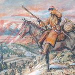
Lieutenant Zebulon Montgomery Pike, two corporals, and 17 privates left Cantonment BelleFontaine, North of St. Louis on August 8th, 1805 with provisions for four months of travel and a keelboat.
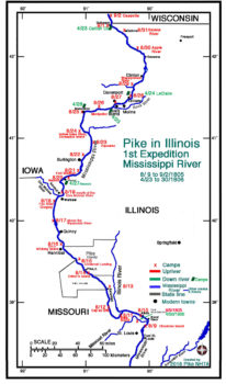
Of the 25 days they spent in Illinois (or adjacent Missouri and Iowa) on the ascent of the Mississippi River, nine encampments were in Illinois and one on an island. On the descent they used many encampments established on the ascent including Catfish Creek on Julien Dubuque’s property (4/23), LaClare, IA (4/24), Muscatine, IA (4/26), Nauvoo, IL (4/27). Return encampments for 4/28 and 29 cannot be determined.
On the return trip they hurried and spent just eight days either encamped in Illinois or Missouri. They were able to move quickly because they were moving downstream.
Pike and his men used they keelboat with sail when they were able. Otherwise they had to pull the boat and their supplies with ropes through sand bars and rapids. It was toilsome and slow on the ascent.
Pike, of course, aided in pulling, noted on his maps geological features, took astronomical latitude readings (using the moons of Jupiter- a long time technique) and met and negotiated with the Indians and French.
At Nauvoo, IL (in Hancock County) on August 20, they met Sac Indians who were flying the US flag. The Sacs helped them move the keelboat up the rapids.
They were able to catch fish to consume, replenishing supplies.


Pike’s field maps (below) are excellent. Matches are good when overlaid on modern maps or compared to the modern map above. The four Pike Field Maps included line up north to south with each other. Plate 12 above 11, 11 above 10, and so on.
PIKE’S FIELD MAPS- Plates 9, 10, 11 and 12


