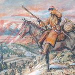
![Introducing the General Zebulon Montgomery Pike INTERNational Historic Trail [ZPIT]](../../../../wp-content/uploads/2018/07/21-St-Anthony-Falls-144dpi-wm-150x150.jpg)


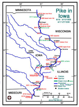
Pike in Iowa (1st Expedition)
Of the 23 days they spent in Iowa (or adjacent Illinois and Wisconsin) on the ascent of the Mississippi River, 11 encampments were in Iowa.
On the return trip they hurried and spent just eleven days either encamped in Iowa or adjacent IL & WS. They were able to move quickly because they were moving downstream. Many of the encampments used on the ascent were again occupied for the descent including Prairie du Chien (4/18-22), Dubuque, IA (4/23), LaClaire, IA (4/24), Muscatine, IA (4/26) and Nauvoo, IL (4/27).
Pike’s expedition visited many French settlements on the Mississippi and Missouri Rivers. The French influence in North America is evident in many locations. The French settled along the St. Lawrence Seaway in Montreal and Quebec City in French speaking Quebec, Canada. The French influence in Canada spread on the Great Lakes to Lake Michigan. Sault Ste. Marie was settled by the French.
In May 1673, Father Jacques Marquette and fur trader Louis Joliet ascended the Fox River at Green Bay, WS, portaged to the Wisconsin River and entered the Mississippi near Prairie du Chien on June 17, 1673. Exploring south on the Mississippi, they stopped at the Arkansas River (435 miles from the Gulf of Mexico) because it flowed through hostile Spanish domains. They returned to Montreal on the Illinois River in mid-July.
France controlled the Louisiana Territory from 1699 until ceding it to Spain in 1762. France regained Louisiana in 1800 when Napoleon hoped to re-establish the French empire in North America.
Vente de la Louisiane - The Louisiana Purchase
American founding fathers, James Monroe and Robert R. Livingston, purchased the Louisiana Territory from Napoleon in 1803.
 During his lifetime, Pike visited French settlements and leaders along the Mississippi River in La Crosse, Prairie des Chien, BelleFontaine, St. Louis, as well as French settlements on the Missouri River. The French had influence over trading and the native population which was needed by the American government. Sainte-Geneviève, MO and Prairie du Rocher, IL were settled by the French.
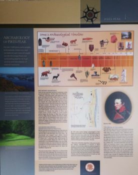
Pike’s Surveying for Future Fort Sites - Pikes Peak State Park, IA
Pike surveyed land near the French settlement of Prairie du Chien, WS and across the Mississippi on the high bluffs in today’s Mendon/McGregor, IA.
Pikes Peak State Park just south of McGregor obviously exists today because of Pike’s surveying it’s bluffs. The ranger at the Park has supplied images of the Pike Memorial (with Pike’s image) at this site which reads in part:
THE ARRIVAL OF EXPLORERS
 “Over 132 years later (after the Marquette and Joliet expedition- 1673) Zebulon Pike explored the area as a suitable site location for a military fort. He determined that with the high bluffs and expansive views it was a good location, however Fort Crawford was actually built down in the floodplain of the Mississippi River and had to move three times due to flooding. As the east expanded westward, the settlers came and communities were developed where the resource provided fertile lands to grow crops, animals for trapping and trade, and a river for transportation and business ventures, as it is still used today.”
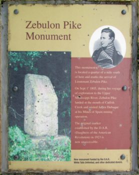
Julien Dubuque and Zebulon Pike Meet
Julien Dubuque in 1788 acquired a Spanish land grant below today’s Dubuque, IA for the “Mines of Spain.” The land was acquired by France in 1800 and then the Americans in 1803. It is said that all three flags had flown over the Mines of Spain.
 Pike met Dubuque on September 1, 1805 and Pike was required to record information about the mines.
According to Pike, “it was impossible for me to make my report by actual inspection,” because of the distance to where the mines were worked, so he posed questions of Dubuque.
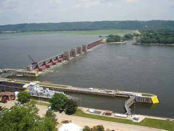
Lock and Dam #11 - General Zebulon Pike Dam
Today’s Lock and Dam #11 (Dubuque, IA) on the Mississippi is referred to by locals General Zebulon Pike Lock and Dam. It stretches for nearly a mile across the Mississippi and is listed on the National Register of Historic Places. It was opened on 14 September 1937.
Pike’s field maps (below) are excellent. Matches are good when overlaid on modern maps or compared to the modern map above. The three Pike Field Maps included line up north to south with each other. Plate 12 above 11, 11 above 10.
PIKE’S FIELD MAPS- Plates 10, 11 and 12


